
GPS navigation apps for iPhone and iPad have come a long way. They can help us with location search, turn-by-turn directions, traffic jam navigation and off-road directions. So whether you’re hiking, traveling or exploring your area, a map app is a must.
In addition, some GPS apps allow you to download maps to conserve mobile data and battery life. But you must update your offline maps regularly to get accurate information.
We already have one GPS app for iPhone: Apple Maps. However, there are more options available, each with a unique set of qualities. Below I have listed the best GPS navigation apps for iPhone.
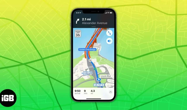
1. Apple Maps – Editors’ Choice
Apple has been offering a pre-installed default GPS app for iPhone since iOS 6. As such, it’s free and available to everyone. I liked its simple user interface and turn-by-turn voice instructions for cyclists, pedestrians and vehicles. It gives the arrival time by calculating the current speed limit and real time traffic data.
In addition, you can access real-time transport information, including bus or train arrival and departure times. In addition, internal maps of the airport terminals show the location of eateries and restrooms.
I got an experience similar to Google Earth with its Flyover Mode and 3D city views. You can also communicate your expected arrival time while cycling, walking, or using CarPlay with Siri to report a traffic incident while remaining hands-free.
pros
- 3D Look Around function
- Efficient lane guidance and speed limit display
- The navigation screen is free from distractions
Minuses
- Can’t download map
- Does not warn drivers of speed traps or obstacles on the road.
Price: Free
2. Google Maps is the best global GPS app
Google Maps offers a very accurate database of places of interest and a map. Plus, with real-time traffic data and redirect automation, you can get to your destination quickly and avoid traffic jams. The best part is that it shows ongoing construction, crashes, potholes, and police presence.
You can view maps in different modes like traffic, public transport, satellite, Google Earth, etc. I made Google Maps the default on iPhone since I mainly use Google’s local search feature to find new places with their opening hours, ratings and reviews, and other important information.
In addition, it syncs your marked location lists and search history across the devices you’re signed in to. You can receive voice guidance in regional languages, change volume settings, and play via Bluetooth.
pros
- Advanced Voice Search
- Accurate directions and location updates
- Street Views for 99% of US Public Roads
Minuses
- Suitable for online use
- Offline maps take up a lot of space
Price: Free
3. Waze is the best for drivers
Waze, a Google offer, brings you the best navigation app for iPhone with the biggest real-time traffic from the community. In this app, local drivers update traffic and route information in real time from time to time.
So, plan your journey accordingly with dynamic routing and save time. In addition, you can find the cheapest gas on your route to save money. But you must have internet access to access the live map and interact with other drivers.
You can also share news about construction, traffic hazards, speed traps and more by connecting Waze to FourSquare, Twitter or Facebook. I liked its compatibility with playing music and podcasts right from the app. Plus, you can use it on your car’s display while driving with Apple CarPlay.
pros
- Real-time traffic information
- Apple CarPlay compatible
- Redirect Automation
- Community of drivers
Minuses
- Screen Advertising
- A little information about the location of attractions
Price: Free
4. Citymapper is the best for transportation
CityMapper allows you to plan your trip in the shortest possible time by comparing transport options. So, whichever way you choose to get around, including walking, cycling or public transport, you can easily get around with step-by-step directions.
In addition, the app offers three different map views, official offline maps, and no-parking zone alerts. Thus, this application will be your travel companion if you live in New York or the San Francisco Bay Area. In addition, you can compare taxi prices, book a rental car, or find an e-scooter nearby thanks to its integration with bike and car rental apps.
I always plan my trip according to waiting times and estimated arrival times so that I don’t miss the bus or train during rush hour. In addition, track your bus or train, check the best car to board, and choose the correct entrance and exit at each subway or train station.
pros
- Connects all transport systems
- Compatible with Apple Watch
- Share your live ETA and location via iMessages
Minuses
- Crashes on older iPhones
- Drains battery too fast
Price: Free (In-app purchases start at $2.99)
5. Avenza is the best offline GPS app
Avenza is my favorite offline map app, perfect for planning adventures or hikes in advance. It offers a large offline map store, including National Geographic maps, national park maps, and more. Plus, you can access premium maps from Garmin, USGS, Michelin, and more.
The Track Your Steps feature tracks you anywhere in the world. In addition, you can create geofences around the world. I liked its integration with what3words to pinpoint your position with custom character sets and alternative coordinate display formats.
In addition, you can import an unlimited number of PDF, GeoPDF and GeoTIFF geographic maps and attach notes, images, and CSV, GPX and KML files. So whether it’s off-road riding or hiking on remote trails, the Avenza is there for you.
pros
- The world’s largest collection of maps for download
- Record GPS tracks and mark places
- Import your own maps
Minuses
- Tracking is interfering with viewing this map
- Interface is not user friendly
Price: Free (In-app purchases start at $0.99)
6. MapQuest – for fans of the night mode
MapQuest provides all the essential features you need to explore and travel across the United States and Canada. You can use voice navigation to get walking or driving directions, or explore areas of interest on a map. In addition, it supports Apple CarPlay and a real-time road camera.
In addition, you can view live satellite images and real-time traffic updates to avoid traffic jams and take alternative routes. I liked its built-in speedometer, which compares your current speed to the posted speed limits on your road. In addition, the multi-point routes feature allows you to set multiple one-stop trips.
You can also use custom symbols to represent your preferred destinations. When planning, I use its layer panel to find and explore nearby points of interest like restaurants, gas stations with the lowest cost, etc. Also, it is one of the GPS navigation apps for iPhone that allows you to find fantastic hotel deals and book them on the app..
In addition, you can view menus, book tables, and place food orders through OpenTable and GrubHub. I think its most unique feature is the local weather updates. But pop-up ads are annoying and interfere with the map view.
pros
- Get real-time traffic updates and route alternatives
- Speed limit display
- Application shortcuts
Minuses
- Doesn’t work properly with Siri
- Navigation features don’t work offline
Price: Free
7. Sygic – Download 3D Maps
The most sophisticated GPS app for iPhone with great navigation options, smart tools, stunning downloadable 3D maps and an intuitive user interface. Multilingual GPS voice guidance gives clear instructions and speaks street names. In addition, offline maps receive regular free updates. If you love exploring cities on foot, this is the app for you.
Because it covers every attraction and tourist site with walkthrough instructions. In addition, you can customize the navigation arrow. More than 500 million people around the world provide real-time traffic information, and Dynamic Lane Assistant helps you avoid traffic congestion. In addition, speed limit alerts display the current speed limit. In addition, the Sygic app highlights your security.
Real View Navigation and Head-up Display technology is useful when driving at night as it projects navigation onto the windshield. After a collision, the DVR instantly captures the video of the surrounding area. In addition, Apple CarPlay connectivity displays all navigational tools on the in-dash display. I liked its wrong path warning (developed in collaboration with Bosch) to know if you are on the wrong path.
pros
- Head-up display
- Real-time character detection
- Dashcam and Cockpit support
- Dynamic lane assistant
Minuses
- Expensive subscription
- Unstable with CarPlay
Price: Free (In-app purchases start at $17.99)
8. MAPS.ME – Find the best hotel
- Requirements: iOS 10.0 and above
If you are looking for an offline GPS app that will drain your battery, then MAPS.ME is the one for you. With ready-made travel guides, you’ll save time organizing your trip and never miss a place or outdoor activity. In addition, the app offers detailed directions to hiking trails, POIs, and other unusual places, and indicates whether the route is uphill or downhill. In addition, millions of OpenStreetMap contributors update maps daily.
It shows hiking trails and other points of interest from MAPS.ME’s extensive database of travel destinations. Along with using streamlined navigation, you can search offline and browse multiple categories such as eateries, travel destinations, hotels, ATMs, and public transportation. Plus, book hotels directly on Booking.com using the app. So, give MAPS.ME a try, as all the free maps are available on the app, as well as a little ad.
pros
- Get the best route
- Search for a location by category
- Bookmark your favorite places
Minuses
- Poor navigation in the countryside
- Doesn’t take the shortest path
Price: Free (In-app purchases start at $0.99)
9. TomTom Go – drive to your photo
- Requirements: iOS 14.0 and above
With TomTom GO, you can enjoy downloadable 3D offline maps that are updated weekly with accurate real-time traffic data. In addition, dynamic lane guidance and simple turn-by-turn guidance help you get to your destination quickly. Speed alerts alert you to stationary and moving speed cameras. With Apple CarPlay, enjoy best-in-class navigation on your car’s display.
Also, I liked its ad-free interface, which is more efficient and privacy-focused. Another unique feature called Go to Photo gives you directions to where your geotagged photos and contact addresses are on your phone. Along with offline maps, you can search the web to find destinations, famous landmarks, and important POIs.
Using accurate distance and time estimates with TomTom Traffic, you can find alternative routes to avoid traffic. Also, you can share your arrival time with others using the messaging service. But the biggest disappointment for me is that you only get 50 miles of free navigation every month. If you want more, you will need to subscribe.
pros
- Downloadable 3D maps for over 150 countries with weekly updates
- Speed camera alerts
- Directions for geotagged photos
Minuses
- The free app includes 50 navigation miles per month.
- iPhone route bar not available in CarPlay
Price: Free (In-app purchases start at $4.99)
10. MapFactor
- Requirements: iOS 11.0 and above
Mapsfactor is one of the best free GPS navigation apps for iPhone from OpenStreetMaps. It offers free offline maps for over 200 countries with monthly map updates. You’ll get real-time HD traffic, door-to-door route and planned trip summary. In addition, speed limits and camera alerts keep you safe. You can set up intuitive voice turn-by-turn instructions in your preferred language.
The premium version of the app offers professional TomTom navigation maps with UK postcodes for more reliable and accurate driving. In addition, I liked the map’s day and night modes with a 2D/3D setting for navigating realistic visual maps. You can change your vehicle information to improve different routes. Plus, the Heads-Up Display and CarPlay support enhance your nighttime driving experience.
pros
- Free maps for over 200 countries
- Customize your vehicle data for an accurate route
- Head-up display for night driving
Minuses
- Bad Search
- User interface is outdated
Price: Free (in-app purchases from $3.49)
So that’s all for today, friends!
You must get the best GPS navigation app for your iPhone if you commute to work daily or like to explore new places. The standalone GPS app has the advantage that it doesn’t drain your iPhone’s battery or generate heat. So which app are you going to download? Let me know in the comments section!