

Most of the time, Google Maps is a flat 2D application and if your device can handle more graphics and a bit more data, you can run the Google Earth 3D dataset and get 3D buildings. At Google I/O, Google announced a new level that flips the graphics slider on Google Maps: Immersive View. The company says that when exploring an area on Google Maps, Immersive View “feels like you’re right there before you even step inside.”
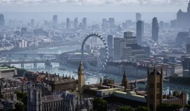
The video for this feature is wild. It essentially turns Google Maps into a 3D version of SimCity with AAA video game graphics. There are simulated cars that drive on the roads and birds fly through the sky. Clouds float overhead and cast shadows on the world. The weather is simulated and the water has realistic reflections that change with the camera. London even has an animated Ferris wheel that spins.
Google can’t track things like individual bird positions (yet!), but a lot of that data is real data. Cars represent the current level of traffic on a given street. Weather represents real weather, even for historical data. The sun moves in real time with the time of day.
The other part of the video shows the flight to the business, which also has a whole 3D layout. All this is possible by combining massive datasets from Google Maps, Google Earth and Street View, but even then this level of accuracy will be very limited by the original datasets. Google says Immersive View will first “begin… rolling out to Los Angeles, London, New York, San Francisco, and Tokyo later this year, with more cities coming soon.”
The company says “Immersive View will work on almost any phone and device,”but like 3D Build Mode, this will be an optional toggle.